![]()
PMLAA
Pine Mountain Lake Aviation Association
|
PMLAA |
|
|
The Pine Mountain Lake Aviation Association (PMLAA) welcomes you to our area. Groveland and Pine Mountain Lake are shared by people with different interests: flying, boating, swimming, fishing, hiking, golfing or just relaxing and enjoying. The Pine Mountain Lake Aviation Association has adopted a Good-Neighbor-Policy and requests that resident and visitor aircraft comply with the noise abatement procedures of the Tuolumne County Airports Department. Craig L. Pedro, Tuolumne County Administrator, in his letter dated November 13, 2009 reminds all the pilots about the noise sensitive areas near Pine Mountain Lake and Columbia airport. Please familiarize yourself with this page for E45 - Pine Mountain Lake (Groveland) Airport, with the Columbia Airport noise abatement procedure, and also with:
Pine Mountain Lake (Groveland) - E45 By using your aircraft's quietest departure techniques and following the guidelines and procedures below, we can reduce the noise impact on our neighbors. Safety always supersedes noise
abatement and Please Use Common Sense and be Considerate to Airport Neighbors
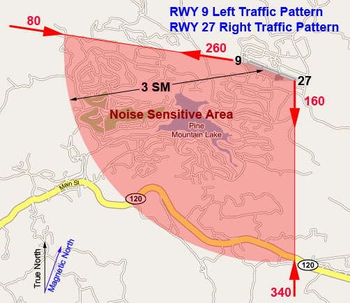
**Most aircraft noise is generated by propeller tip noise. This is especially true when propeller tip speeds approach supersonic speeds. Even a small reduction of 100 to 200 RPM can produce a significant decrease in noise levels. You can learn more about this at http://www.pponk.com/HTML%20PAGES/propellers.html Noise Sensitive Area Do NOT Fly over the Lake below 4,550’ MSL.
This area is included in the sector delimited by
Suggested VFR Departure Procedures RWY 27
Suggested VFR Departure Procedures RWY 9
Suggested VFR Arrival Procedures RWY 9 and RWY 27
Additional considerations
Safety always supersedes noise
abatement and PMLAA assumes no responsibility for the accuracy, completeness or appropriateness of the information provided above and shall not be liable for its content, or for any errors or interruptions in the transmission of data. PMLAA shall be under no obligation to correct any inaccuracies in this information and shall not be required to revise, amend or supplement same. This data is not, and is not intended to serve as a substitute for or in fulfillment of pilots' responsibilities under pertinent Federal Aviation Regulations to obtain current and appropriate weather and pre-flight briefings and airport information from FAA-approved sources. |
|
Copyright 2004, 2005, 2006, 2007,
2008. 2009, 2010 PMLAA |